Scottsdale’s elevation climbs from 1,200 feet in the south to over 2,500 feet near the McDowell Mountains, creating a patchwork of valley fill, cemented alluvium, and decomposed granite that shifts unpredictably the moment you break ground. A 2023 commercial excavation near the Loop 101 corridor encountered a lens of collapsible silt at 14 feet that standard borings had missed entirely, halting work for three weeks while the design team scrambled for a fix. That kind of delay in a city where summer temperatures routinely exceed 105°F translates directly into budget overruns and safety risks that no contractor wants to explain to an owner. Geotechnical excavation monitoring closes that gap between what the pre-construction report predicts and what the shovel actually reveals, giving your team real-time data to adjust shoring, dewatering, and sequencing before a minor anomaly becomes a shutdown event. When the ground surprises you, the difference between a two-day adjustment and a two-month headache is the quality of the instrumentation watching it.
Real-time inclinometer data lets you backfill a soldier pile wall with confidence instead of crossing your fingers.
How we work
Local ground factors
The most expensive mistake we see in Scottsdale excavation projects is treating monitoring as a post-hoc documentation exercise rather than a proactive risk management tool. A contractor who waits until a neighboring pool deck shows a hairline crack before installing crack gauges has already lost the ability to prove whether the movement was pre-existing or excavation-induced, and that ambiguity almost always ends in a legal dispute that costs far more than the monitoring contract ever would. The caliche layers common in north Scottsdale can create a false sense of security because they stand vertically without support for weeks, then fail catastrophically when a summer monsoon saturates the underlying silt and destroys the apparent cohesion. Our monitoring program triggers a mandatory visual inspection every time a piezometer records a pore pressure spike above 80% of the design threshold, so the superintendent gets a warning call before the wall gets a bulge. In a city where the average single-family home now exceeds $800,000, the liability exposure from unmonitored excavation is simply not a rational business risk.
Explanatory video
Reference standards
IBC 2021 Chapter 33 – Safeguards During Construction, ASCE/SEI 7-22 Minimum Design Loads and Associated Criteria, OSHA 29 CFR Part 1926 Subpart P – Excavation Safety, ASTM D6230 – Standard Guide for Monitoring Ground Movement Using Probe-Type Inclinometers
Complementary services
Shoring & Retaining Wall Performance Monitoring
Continuous inclinometer and tiltmeter tracking of soldier pile, secant, and soil nail walls, with automated alerts when lateral deflection exceeds 0.5% of wall height. We correlate movement data with excavation stage, dewatering activity, and temperature to distinguish structural distress from normal thermal cycling.
Adjacent Structure Protection Surveys
Pre-construction crack mapping, vibration monitoring, and optical survey prism networks on neighboring buildings, pools, and hardscape. We deliver a baseline condition report that becomes your insurance policy against exaggerated damage claims.
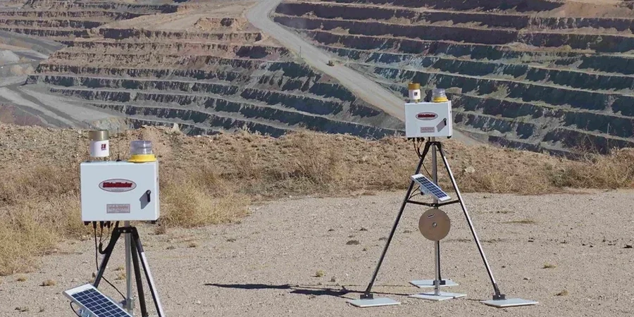
Groundwater & Pore Pressure Control
Standpipe and vibrating wire piezometer arrays tied to real-time telemetry, designed specifically for the perched water zones common in the Salt River Valley. Data feeds directly into the dewatering contractor's pump schedule to prevent base heave and piping failures.
Typical parameters
Common questions
What does geotechnical excavation monitoring typically cost for a Scottsdale project?
For a standard commercial excavation in Scottsdale with three to five monitoring stations, including inclinometers, crack gauges, and a piezometer array, budgets generally run from US$840 to US$2,330 per month depending on instrument density and reporting frequency. A small residential hillside cut might fall on the lower end, while a deep mixed-use excavation adjacent to occupied structures with automated telemetry will trend toward the upper range. We provide a fixed-scope proposal after reviewing the shoring drawings and the geotechnical baseline report so there are no surprises.
How often do you take readings during the excavation phase?
During active digging and shoring installation we read inclinometers and survey prisms daily. Piezometers and vibration monitors can be set to continuous logging with threshold alerts. Once the excavation reaches final grade and the permanent structure begins to rise, the frequency typically steps down to twice weekly, then weekly, based on the observed trend stability. Every client gets a written monitoring action plan that defines exactly when and why the reading interval changes.
What happens if an instrument triggers an alert level?
The monitoring action plan specifies a tiered response. An amber trigger—say, lateral movement reaching 70% of the design threshold—prompts an immediate field inspection by our engineer and a same-day phone call to the superintendent. A red trigger at 100% of threshold triggers a stop-work recommendation, a full survey of all instruments, and a conference call with the design engineer of record within four hours. Every alert is documented with time-stamped data and a written summary, which protects all parties if a dispute arises later.
Do you monitor during monsoon season differently?
Absolutely. Monsoon storms between June and September can drop an inch of rain in under an hour on Scottsdale soils that have very low infiltration capacity, creating rapid runoff that finds its way into open excavations and erodes unsupported faces. We increase piezometer reading frequency to at least twice daily during active monsoon watches and add a mandatory visual inspection of all surface drainage controls within 24 hours of any storm exceeding 0.5 inches. The monitoring plan also includes a pre-monsoon calibration check on all electronic instruments to ensure heat and dust have not caused any drift. More info.