The subsurface contrast between Scottsdale's northern reaches and its southern basin is striking. Up near Troon, decomposed granite and fractured bedrock create one resistivity signature; down south toward the Salt River Pima-Maricopa Indian Community boundary, the interbedded sands, gravels, and evaporite-rich clay lenses paint a completely different picture. Vertical Electrical Sounding cuts through the guesswork. By driving a controlled current into the ground and measuring the potential difference at expanding electrode spacings, we map how resistivity changes with depth—revealing the boundary between coarse alluvium and fine-grained basin fill, the top of a buried caliche hardpan, or the transition into saturated sediments. The same raw desert terrain that makes Scottsdale a geological puzzle also demands geophysical methods that work without trenching through protected arroyos or disturbing sensitive Sonoran habitats. Our field approach integrates the VES data with direct sampling from test pits to anchor the resistivity model to observed lithology, ensuring the interpretation reflects real ground conditions rather than just mathematical inversion.
A clean VES curve in Scottsdale's basin-fill deposits reveals more about foundation risk than a dozen borings spaced too far apart.
How we work
Local ground factors
The most common mistake we see occurs when a Scottsdale project relies solely on drilling logs spaced several hundred feet apart and assumes the stratigraphy is continuous. Basin-fill deposits here are notoriously lens-shaped: a gravel channel that vanishes laterally into silty clay, or a perched saline water pocket that no one anticipated. A VES survey bridges the gap between boreholes, detecting those lateral transitions before excavation begins. Without that continuity check, the contractor risks encountering unexpected saturated fines in a cut, triggering a slope stability issue or a dewatering delay that the budget never accounted for. The caliche layer adds another layer of danger—mistaking it for competent bedrock in a resistivity section can lead to an undersized footing design, because the true bedrock sits another 40 feet below the caliche cap. Our approach treats the VES not as a standalone curiosity but as a spatial interpolation tool that reduces the probability of a costly subsurface surprise during construction.
Reference standards
ASTM D6431-18 Standard Guide for Using the Direct Current Resistivity Method, IBC 2021 (Chapter 18: Soils and Foundations, reference to ASCE 7 for investigation scope), ASCE/SEI 7-22 Minimum Design Loads (Section 3.2 for site investigation requirements)
Complementary services
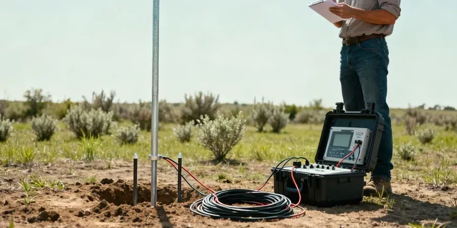
Vertical Electrical Sounding (VES)
1D resistivity depth profiling using the Schlumberger array to map stratigraphic layering, depth to groundwater, and the thickness of caliche hardpan across Scottsdale basin sites.
Wenner Resistivity Profiling
Lateral resistivity mapping at fixed electrode spacing to delineate buried channel boundaries, fault traces, and contaminant plume edges in alluvial settings.
Borehole-Controlled Geophysical Correlation
Calibration of resistivity models against SPT boring logs and test pit lithology to convert apparent resistivity into actionable geotechnical layering.
Typical parameters
Common questions
How much does a VES survey cost for a typical Scottsdale residential lot?
For a standard residential or small commercial parcel in Scottsdale, a VES survey with four to six soundings and a basic interpretive report typically runs between US$650 and US$970. The final number depends on access conditions—pulling cable across a manicured McDowell Mountain-area lot is straightforward; working through a raw desert parcel with dense cholla and uneven terrain adds mobilization time.
Can VES detect the depth to groundwater in Scottsdale's basin-fill sediments?
Yes, with an important caveat. The resistivity contrast between dry alluvium and saturated sediments is strong in Scottsdale's coarse-grained deposits, so the water table often appears as a clear low-resistivity horizon. However, if the groundwater is highly saline—which occurs in some deeper basin zones—the resistivity drop can be sharper than expected. We always calibrate the geophysical contact against at least one monitoring well or borehole log to confirm the interpreted depth.
What is the difference between VES and ERT, and which one should I use?
Vertical Electrical Sounding (VES) assumes a 1D layered earth and uses one expanding array to model resistivity versus depth at a point. Electrical Resistivity Tomography (ERT) uses multiple electrodes along a line to produce a 2D cross-section. VES works well for layered basin stratigraphy where we need depth control at a few key locations; ERT is better for detecting lateral changes like paleochannel edges or fracture zones. On many Scottsdale projects we combine both—VES for reconnaissance depth information and ERT lines for detailed cross-sections.
How long does it take to complete a VES survey and receive the report?
A field crew can typically complete four to six soundings in a single day on an accessible Scottsdale site. Data processing and 1D inversion take another two to three business days, and the interpretive report—including correlation with any available boring logs—is delivered within five to seven business days after field completion. Rush turnaround is available when needed to meet a fast-track construction schedule.